
The stunning Malham Cove.
A Friday off work and with the world my running lobster, I decided to set off for Malham, a truly beautiful corner of the world. I have walked the classic Malham round on many occasions and the appeal of running in "the wilds" without navigating was very appealing. The classic round is not much more than 6 miles however, so I decided to extend it somewhat. A trip round the back of the tarn seemed to fit the bill.
Usually, the round is thus: From Malham to the cove. Up the 300+ steps to the top. Along one of the valleys to the tarn. Lunch at the waterside, then down through Gordale scar, along past Janet's Foss and back to Malham. I didn't feel that 6 miles would justify an hour's drive so I decided to add on a little "getting lost" session behind the tarn to extend the run to about 10 miles. I know my way around part of the back of the tarn (It's only one path, it'd be tough to get lost) but didn't know exactly how to keep going right around the back then join up with the path back to the cove. Still, it didn't look that hard. I decided to do the route in the opposite direction to usual, that way I would be able to take the path I knew around the back of the tarn and then find my way from there. What could possibly go wrong?
I could forget my map.
But I would never be stupid enough to do that, would I? Hmmmmm, good job I committed it to my photographic memory before I set off *cough*


A quick trot across the ancient stone bridge and I was on the path back to Malham, which was getting a bit over grown.

I was happy to provide a moving buffet for a variety of flying insects as I moved along the path and they certainly dined out. Hope I was tasty.
The run back to Malham flew by and I settled down in one of the local cafes after discovering it wasn't possible to buy a newspaper in Malham!

The moist carrot cake was absolutely delicious and even better, the waitress decided the last 2 pieces of it were too small so gave me both to make one giant slice. Maybe I looked like I need it after 10 miles.


I could forget my map.
But I would never be stupid enough to do that, would I? Hmmmmm, good job I committed it to my photographic memory before I set off *cough*
 |
| Malham: Yorkshire cliche No5. |
Having avoided the wooly "traffic" in Malham, I set off for the Janet's Foss. This involved a run down a track that follows the side of a lovely stream and through a forest. Even though I wasn't running fast and the way was easy and flat, I was already blowing quite hard soon in to the run. It had to be due to there being some actual heat for once! I started to receive the first of many odd looks I got from the walkers that day. It wasn't that long ago I was one of those walkers looking with incredulity at the runners. I didn't pass a single other runner the whole day.
 |
| On my way to Janet's Foss. The wild garlic was out in force |
It's not far to Janet's Foss but by the time I got there I already needed a rest, so I stopped and took some photos and had a drink.

Janet's Foss is a little waterfall if you didn't know. Faeries live here. Yes they do.
The next stop was Gordale scar, also, not very far away. I have never climbed up the scar, only down, so it would be a new experience. The scar is very dry at the moment, so I knew that it wouldn't be too difficult.

Shame there is nothing in this pic for scale; to give you an idea, the bottom waterfall is probably about a 30ft drop
The climb proved quite easy with the lack of water and was great fun as always.

The view from the second, higher waterfall looking down through the scar.
On reaching the second waterfall there is a long set of rough-hewn steps to negotiate before running along a valley to the tarn. The climb up the scar and the steps isn't for the faint-hearted and I have scared the life out of several people with it, but in reality, it's really not very hard; if you've ever climbed at all, you wouldn't struggle and I have got several people down through it who have never climbed before.
The run continued through the gorgeous countryside in glorious sunshine and it wasn't very long before I arrived at the tarn.

It wasn't actually dull, but I can't be arsed to correct the light in photoshop
As I got around the "back" of the tarn, I stopped at a beautiful viewing point and had a bite to eat and a drink. The clif bar went down especially well. The deuter waist pack is just large enough to carry the things I need on a warm day.


Nom, nom, as they say, nom
Now it was time for the adventure to start; find my way around the back of the tarn with only the magnets in my head and a vague recollection of a map to go by. I basically navigated by heading in the direction I thought the cove was. Amazingly, it worked and I soon found the road I needed and headed down the valley towards the cove.

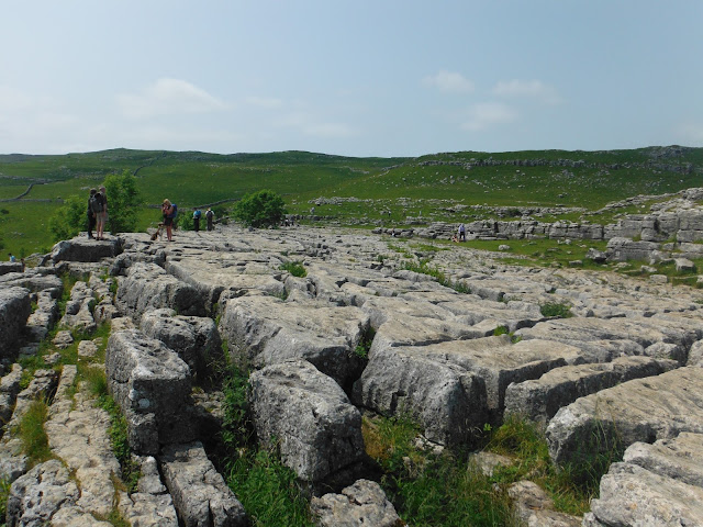
The valley isn't very long and I soon hit the famous limestone pavement.

The limestone walk is slippery as the Devil's banana skin in winter, but this day it was dry and easy to run on. The cove itself is, essentially, a giant cliff. Once upon a time it was a waterfall bigger than Niagara, but that was a few thousand years ago, so I missed it.

The view from the top of the cove is stunning.
The looks of incredulity increased tenfold as I ran down the steps of the cove but everyone was very kind in making sure they gave me enough room to get by.

Looking back up from the bottom of the cove steps. These are just the first few....

Always nice to linger at the bottom of the cove.


A quick trot across the ancient stone bridge and I was on the path back to Malham, which was getting a bit over grown.

The run back to Malham flew by and I settled down in one of the local cafes after discovering it wasn't possible to buy a newspaper in Malham!

The moist carrot cake was absolutely delicious and even better, the waitress decided the last 2 pieces of it were too small so gave me both to make one giant slice. Maybe I looked like I need it after 10 miles.

The local wildlife is very friendly/cheeky.
Malham is a truly beautiful place to run and navigation is pretty easy, which is always a bonus to me! I picked a lovely, if rather hot, day. Bonus! If you haven't been to Malham yet, why not?

Here's the run wot I did, as seen in google earth.
My Garmin had a strange freak-out and decided that I had also run back to Leeds afterwards and drew it on the map, yet didn't add the distance. Odd. But here's the run on Garmin connect
My Garmin had a strange freak-out and decided that I had also run back to Leeds afterwards and drew it on the map, yet didn't add the distance. Odd. But here's the run on Garmin connect
No comments:
Post a Comment